
It can’t have escaped most people’s attention that the recent release of Internet Explorer 11 contains support for WebGL (IE11 Dev Center). Now that advanced 3D graphics are becoming possible on all platforms, visualisations like the Realtime 3D Tube Trains that I posted about a while ago are likely to become mainstream.
On a similar theme, I’ve been looking at the open source AgentScript library which is a port of the popular NetLogo agent based modelling library to CoffeeScript and Javascript. CoffeeScript is a library to make writing Javascript easier, but my aim was to see whether it could be made to work with Google Maps to build dynamic maps with geospatial agent based models running on them. Going back to the 3D tube trains example, this could allow us to build a model which used realtime data from the TfL API to get the actual positions of trains, then run a “what if” scenario if a tube line failed to try and predict where the biggest problems are likely to occur. In short, the idea is to allow code to be run on maps to make them dynamic (see: http://m.modelling4all.org/ for another website which allows users to publish models).
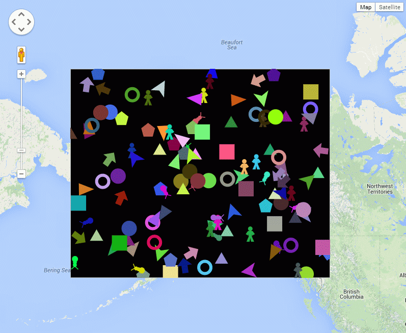
AgentScript (in CoffeeScript) running on a Google Map. If you haven’t see the example, the multi-coloured agent shapes move around randomly.
The example shown above was the result of just a few hours work. It’s actually the “sketches/simple.html” example from the GitHub repository, but I’ve taken out the patches.
The code to achieve this is basically a modification of the standard Google Maps code to convert it to CoffeeScript, which then allows for the integration with AgentScript. The code is shown below:
[code language=”javascript”]
<script type="text/coffeescript">
#######################################################
#Google Map
#######################################################
map = null
mapOptions = null
initialize = () ->
google.maps.visualRefresh = true
mapOptions =
zoom: 8
center: new google.maps.LatLng(62.323907, -150.109291)
map = new google.maps.Map(document.getElementById(‘map’), mapOptions)
swBound = new google.maps.LatLng(62.281819, -150.287132)
neBound = new google.maps.LatLng(62.400471, -150.005608)
bounds = new google.maps.LatLngBounds(swBound,neBound)
overlay = new AgentOverlay ‘layers’, bounds, map
class AgentOverlay extends google.maps.OverlayView
constructor: (@id_, @bounds_, @map_) ->
console.log("Building AgentOverlay called ‘"+@id_+"’")
@div_=null
@setMap(@map_)
onAdd: () ->
div = document.createElement(‘div’)
div.id=@id_
div.style.borderStyle=’none’
div.style.borderWidth=’0px’
div.style.position=’absolute’
div.style.backgroundColor=’#f00′
@div_=div
panes = this.getPanes()
panes.overlayLayer.appendChild(div)
draw: () ->
overlayProjection = @getProjection()
sw = overlayProjection.fromLatLngToDivPixel(@bounds_.getSouthWest())
ne = overlayProjection.fromLatLngToDivPixel(@bounds_.getNorthEast())
div = @div_
div.style.left = sw.x+’px’
div.style.top = ne.y+’px’
div.style.width = (ne.x-sw.x)+’px’
div.style.height = (sw.y-ne.y)+’px’
model = new MyModel "layers", 10, -25, 25, -20, 20, true
model.debug() # Debug: Put Model vars in global name space
model.start() # Run model immediately after startup initialization
onRemove: () ->
@div_.parentNode.removeChild(@div_)
@div_=null
google.maps.event.addDomListener window, ‘load’, initialize
</script>
[/code]
While this demonstrates the idea of adding an AgentScript Canvas element to a Google Maps overlay, there are still issues with getting the canvas box in the correct position on the map (at the moment it stays in the same position when you zoom out, but the scrolling works). Also, the agents themselves are moving on a flat surface, while the four corners of the box are specified in WGS84 and reprojected to Spherical Mercator by the Google Maps library, so there is a coordinate system issue with the agents’ movement. Despite these issues, it still makes for an interesting proof of concept of what could be possible.