Three Days and Two Nights at the Museum

As part of the ESRC Festival of Social Science, CASA and Leeds University held a three day event at Leeds City museum called “Smart Cities: Bridging the Physical and Digital”. This took place on the 8th, 9th and 10th of November.

The London Table and City Dashboard on the main overhead screen, plus tweetometer on the side screens

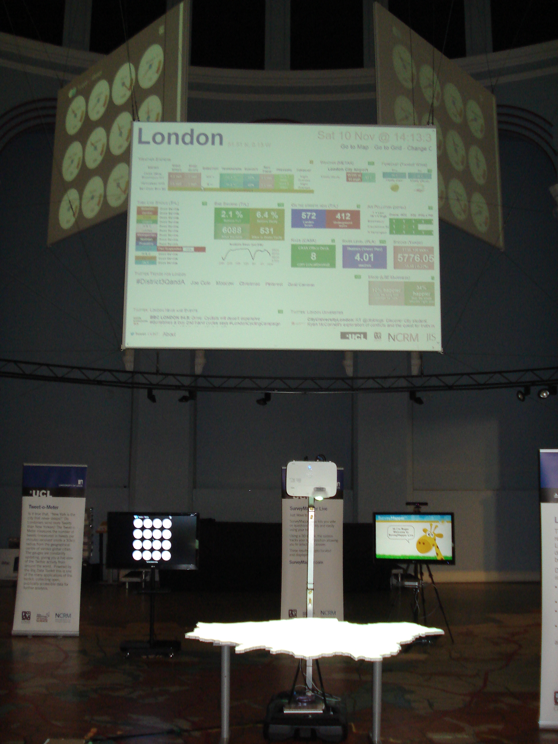
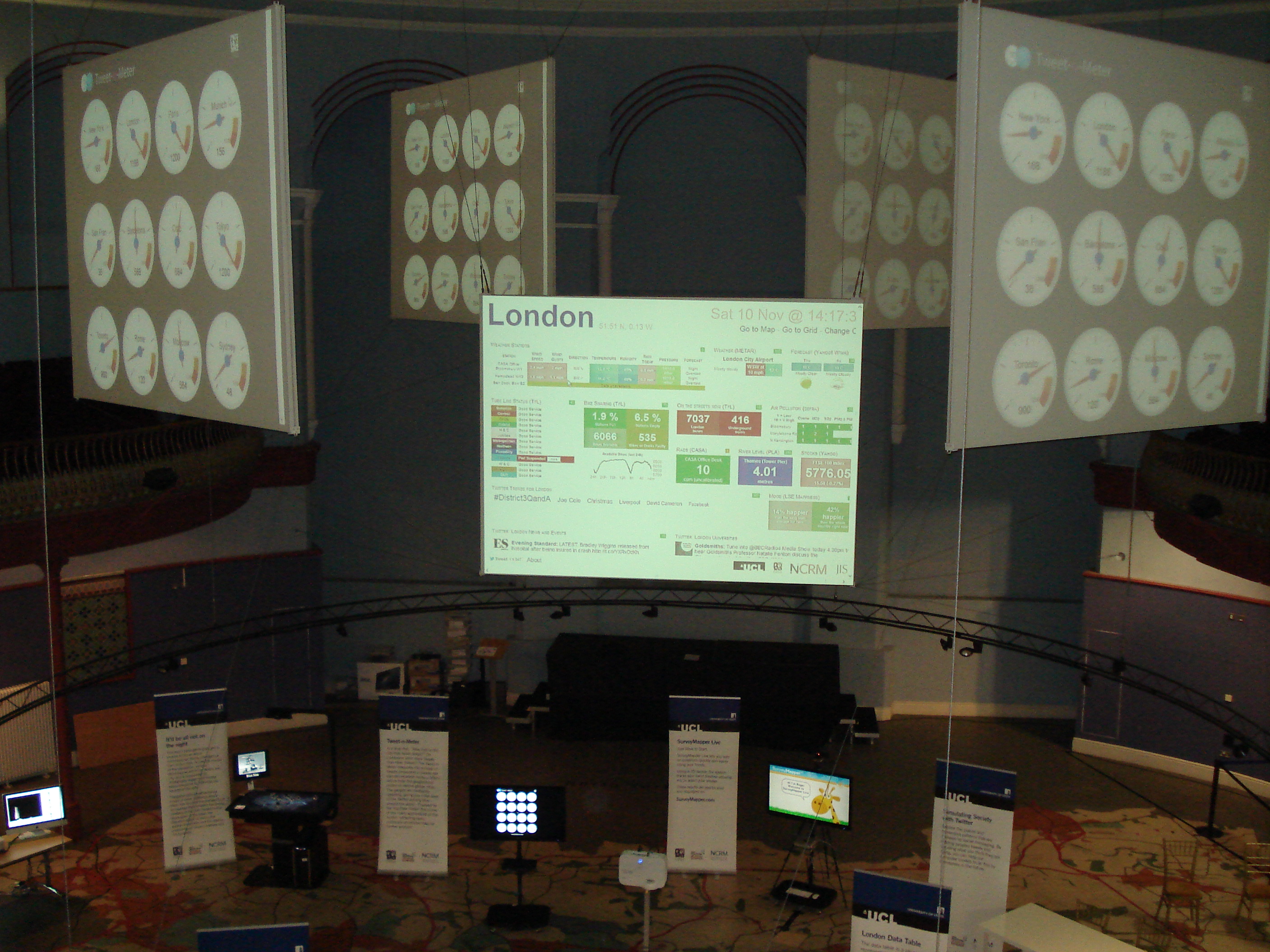
The museum’s central arena venue for the exhibition was a fantastic choice because of the domed roof and suspended overhead screens (see picture). There was also a map of the Leeds area set into the floor and a gallery on the first floor where people could look down on the exhibits and take pictures.

The timing of the event also coincided with a market in the square outside and a number of children’s events taking place in the museum on the Saturday, so we had plenty of visitors.

Although this was a follow-up to the Smart Cities event which we did in London in April, there were a number of additions and changes to exhibits. Firstly, we added a second pigeon sim which was centred on Leeds City museum, in addition to the London version centred on City Hall. Although we expected the Leeds one to be popular, people seemed to be fascinated by the London version and the fact that you could fly around all the famous landmarks. I spent a lot of time giving people directions to the Olympics site and pointing out famous places. Having watched a lot of people flying around London it might be interesting to see how it changes their spatial perception as a lot of people don’t realise how small some things are and how densely packed London is.

Leeds Pigeon Sim and Riots Table
The Leeds Pigeon Sim on the left, with the image on the projector showing Leeds City museum

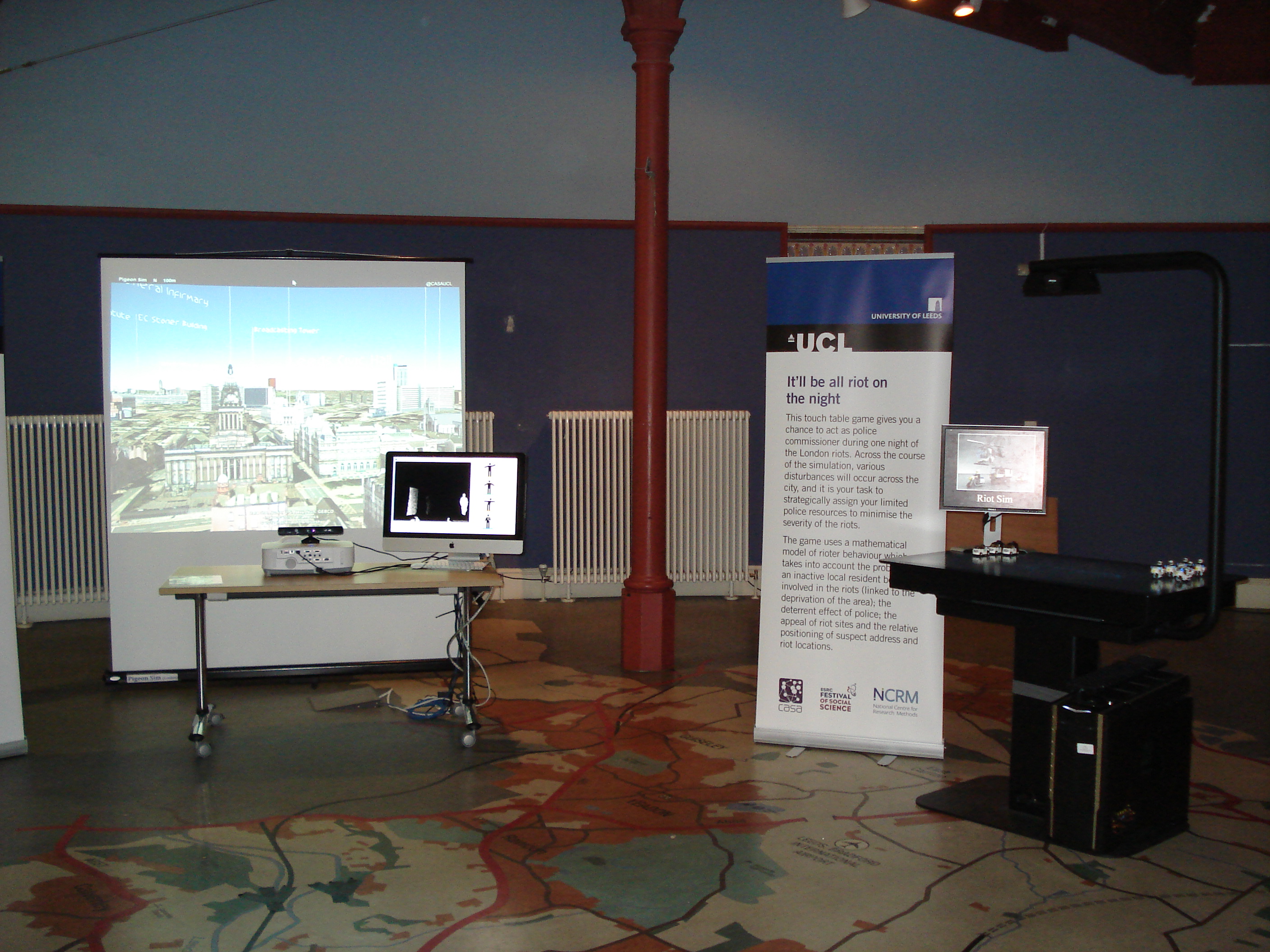
Both the pigeon sims use Google Earth, controlled via an XBox Kinect and its skeleton tracking. This has always worked very well in practice, but did require some height adjustment for the under fives. The image on the right also shows the riots table which uses another Kinect camera to sense Lego Police cars on the surface of the table. A model of the London riots runs on the computer and displays a map on the table which players use the Police cars to control. The Lego cars survived fairly well intact, despite being continually broken into pieces and lots of children enjoyed rebuilding them for us.

Another change to the London “Smart Cities” exhibition was the addition of the HexBug spiders to the Roving Eye exhibit. Previous posts have covered how a HexBug spider was modified to be controlled from a computer.

The Roving Eye and HexBug Spiders table showing the computers that control both parts with a spider on the table in the middle

The original “Roving Eye” projected “eyeball” agents onto the table and used a Kinect camera to sense objects placed on the table which formed barriers. The addition of the HexBug spider adds a physical robot which moves around the table and can be detected by the Kinect camera, causing the eyeballs to avoid it. This exhibit is built from two totally separate systems, with the iMac, Kinect and projector running the Roving Eye processing sketch (left computer), while the Windows 7 machine (right) uses a cheap webcam, Arduino, OpenCV and modified HexBug transmitter to control the spider. This is an interesting mix of the “Bridging the Physical and Digital”, and there were a lot of discussions with visitors during the three days of the exhibition about crowd modelling in general.

Also new for the Leeds exhibition was the Survey Mapper Live exhibit, which allows people to vote in a Survey Mapper survey by standing in front of the screen and waving their hand over one of the four answers.

Survey Mapper Live

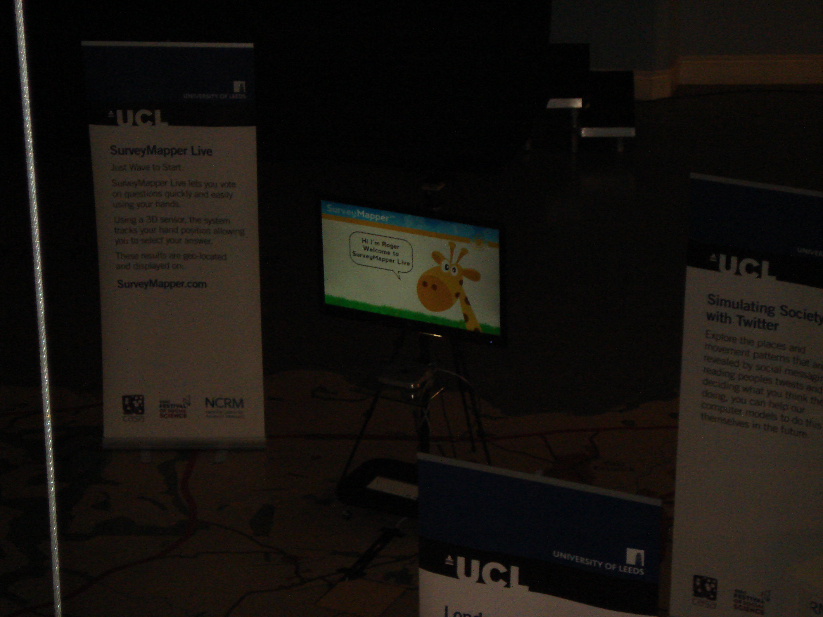
The question asked was about increased Leeds independence and over the course of the three days we received a good number of responses. The results will follow in another post once they have been analysed, but, for a first test of the system, this worked really well. The aim is to put something like this into a public space in the future.

Finally, the view from the gallery on the first floor shows the scale of the event and the size of the suspended screens.

Looking down from the gallery
Five Screens

Flexible Modelling Framework

Work is starting this week at the Centre for Spatial Analysis and Policy (CSAP) in Leeds on preparing the Flexible Modelling Framework (FMF) for release under an open source licence.  The FMF so far includes the following capabilities: microsimulation (using simulated annealing); spatial interaction modelling and agent-based modelling.  The idea behind the framework is to give researchers a tool where common modelling methodologies can be linked together and developed.

The FMF has been developed in the Java programming language.  The FMF has initially been used for generating realistic populations of Leeds (Harland et al., 2012: http://jasss.soc.surrey.ac.uk/15/1/1.html ) and is currently being used to examine trends and processes within retail markets.  Other applications, ranging from modelling health behaviours to influence of autism in early modern human populations are being planned.

The simulation capabilities of the FMF will also be made available under short TALISMAN tutorials and possibly TALISMAN social simulation courses in 2013.

Further information on the release and further functionalities will be added in due course.

The Flexible Modelling Framework

Harnessing Unique Methods of Visualisation

The first time I saw a tube map of London was a long time before I actually ever went there. It was during my one summer living in downtown Toronto with a bunch of crazy girls. One of the saner ones had a poster of the tube on her bedroom wall. It was from the Tate Gallery, where the different tube lines were created with thick lines of paint, which I’ve found again here. At the time, I found this poster really fascinating. If you know anything about the underground in Toronto, it’s pretty uninteresting and wouldn’t make much of a visual object!

Then more recently, I came across a super wacky map of the London Underground made by Franceso Dans, a visitor to UCL from Goldsmiths spending 6 weeks in CASA. You can view his map and his motivation behind this amazing construct on his blog. He’s working on more of these tube maps for different cities as well as an application that will allow you to travel from A to B anywhere in the world without using an airplane. He’s harvesting all the information, e.g. train and bus timetables, from the internet to build the site.

If you’d like to spend some time at CASA working with experts in visualisation, digital media, data harvesting and crowdsourcing, then consider applying for one of our User Fellowships. CASA has developed a number of interesting ways of visualising ‘big data’ that might benefit your organization. Or maybe you have an interest in crowdsourcing and seeing how you can harness the power of the crowd in providing data. Or you’d like to see what analysing twitter feeds might mean for your business. If you are a non-academic and want to work with CASA on a project where you could pick up some visualisation or data analysis skills, then apply for a User Fellowship. The deadline is 21 Sep 2012 and there’s more information on the TALISMAN website.

Picking Up Raster GIS Skills

Do you need to work with satellite images or datasets that are gridded? By gridded I mean data that are stored in grid like cells such as heights of the earth (or a digital elevation model), a global land cover map or gridded populations of the world? There are many other gridded datasets available, e.g. climate data, maps of biomass, ecosystem services, etc.

Example of a satellite image on the left and a LIDAR DEM on the right

Or have you collected data using a GPS that you need to interpolate to a continuous surface like that shown below:

An example of interpolating points to surfaces

If the answer to any of these questions is yes, or if you’ve suddenly realised this might be useful for your research,  then come and learn more about raster data and how to manipulate these datasets in a Geographic Information System (GIS). On 26-27 July 2012, Dr Steve Carver will teach a 1.5 day course at the University of Leeds on how to work with raster datasets using ArcGIS. This course is open to staff and students at Higher Education institutions in the UK and Ireland.

The course will cover the following topics with practical exercises throughout to gains hands-on experience with the concepts and the software:

  1. Introduction to raster modelling in ArcGIS
  2. Importing and converting raster data
  3. Point-surface interpolation
  4. Digital elevation models and terrain analysis
  5. Cartographic modelling (which allows you chain processes together in a work flow and automate your modelling)

You can register for the course on the TALISMAN website or email Amy O’Neill if you have any questions. Alternatively, if you catch this post after the course has taken place, contact Amy and let her know that you are interested in future courses.