
Streams 4 and 5: Data Sourcing and Visualisation
Data sourcing involves pulling in what is usually large amounts of geospatial information in real-time and then visualizing and analyzing these data streams. These are particular areas of expertise within CASA, where ongoing developments are taking place within the Talisman project.
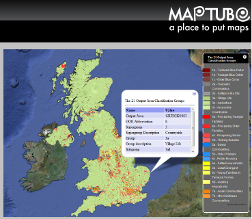 MapTube is a software package for creating, sharing and publishing maps on the internet which was originally developed under the ESRC GENeSIS project. Further development of the MapTube application is continuing under TALISMAN. The latest release of MapTube (19/12/11) allows handling of data directly from shapefiles, providing a key piece of infrastructure to make it possible to visualise model outputs in aggregated form. The MapTube website provides examples of many different visualisations of data on Google Maps including air temperature from Weather Underground and a geographically correct London tube map.We are currently building a web-based data visualisation
 infrastructure for MapTube to allow on the fly visualisation of 2D geospatial data.
A text based analysis tool is in development as a mobile app called Textal, which is based on the research needs of the Digital Humanities group at UCL with a focus on text mining methods and visual analytics.
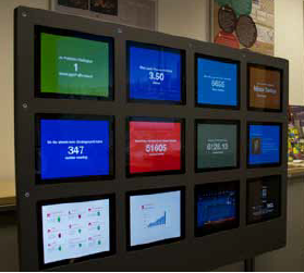
An iPad visualization wall was installed at the London Mayor’s Office to display real-time data on air quality, finance and the state of London’s transport systems. More information can be found on this blog,in the MethodsNews Spring 2013 newsletter and in the latest BBC report on Smart Cities.
CASA has implemented the Transport For London Trackernet API to obtain real-time information on locations of Tube trains and published on MapTube as a resource, which can then be visualized.
CASA has developed an autoDesk 3DS Max and FBX exporter with a view to using XNA – this is an important step in opening up a framework for modelling visualisation. Coding is ongoing to put in place a WebGL example and Collada export for NetLogo to allow complex three-dimensional visualisation of agents. In addition workflows have been developed to visualise data in Lumion.
Work is ongoing mining Internet Data Stores for geospatial information starting with the London Datastore, where datasets can be geo-referenced and visualised automatically. Classification and advanced visualisation methods are currently being developed.
CASA is currently running a feasibilty study on big data platforms for live data collection systems with respect to crowd-sourcing real-time data feeds. As part of this work, the speed of writes / fetching data and automatic scalability of platforms for dynamic data collection are being investigated.
Richard Milton has been carrying out investigations into the use of Hadoop MapReduce architecture for large-scale spatial analysis and visualisation. A method has been developed for using geotools with a computer cluster to achieve a high degree of scalability on data parallel tasks. This will continue with a WPS implementation to provide a scalable infrastructure for complex spatial data analysis.
Richard has also been working on the analysis and visualisation of real-time transport data for buses, tubes and trains. He has been developing stream mining methods to detect failures, off-line analysis of failure rates and joint probabilities of failure. Visualisation methods have been developed for average wait times using 3D rendering in Processing, along with real-time statistics using stream graphs and other features extracted from the data stream. Real-time 3D visualisation of large numbers of animated agents (buses and tube trains) using HTML5 and WebGL has been developed.
Richard Milton has been working on integrating AgentScript with Google Maps to allow geospatial agent based models to be displayed on a map in a way analogous to using NetLogo and the GIS plug-in. This is the “ModelTube” deliverable which is part of work package 5, and will allow real-time visualisation of data on the sand table which was demonstrated at the Smart Cities Conference (27 Sep 2013) by RedFish. This work follows on from the HTML 5, WebGL and Canvas developments reported in the last quarter and other major improvements to the web-based geospatial data visualisation framework, which will be rolled out in the new year. New sources of data about cities have also been included in CASA’s monitoring framework, partly as a result of Hacking the Smart City (7 to 9 Nov 2013), and the amount of environmental data that we can now collect and visualise has been increased. Richard’s work on large-scale geospatial processing and visualisation using cloud infrastructure is still ongoing.